© 2026. Randolph Hub. All Rights Reserved.
Welcome!
From the Faith Rock Trailhead, cross this historic bridge and follow the trail through woods with beautiful views of Deep River to the top of Faith Rock, a natural heritage site with rare plants. (Photo: https://www.piedmonttrails.org)
So you want to hike? Here are many local possibilities
The first step to taking a hike is wanting to do so, of course.
Maybe you feel the need to get in better shape, or maybe to just get prepared for a vacation where you’re going to have to do quite a bit of walking. Maybe you’re bored and it’s a nice day outside. Maybe you want to get out on your own for a bit to do some thinking, or meet a friend or two to talk some things over. Maybe you just feel like communing with nature, seeing an interesting site, putting yourself in touch with local history.
That’s just scratching the surface of finding reasons to do yourself some good.
Once you’re ready for that first step, then you consider your limitations. Can you handle any terrain? Would you prefer flat to hilly paths? Are you a little unsure of your footing? Are you a little leery of walking a natural path versus a gravel or paved one? Are you afraid of getting lost in the woods?
They’re all good questions. Maybe your “hike” is more like walking 5 or more miles on paved, marked pathways throughout the NC Zoo. No shame in that. I gave a visiting cousin and her husband a tour once, and she used a wheelchair to stroll the distance while we walked; believe me, it’s a workout, especially as she zipped along while we tried to keep up.
Or to a smaller extent, another easy pick is to do a lap on the paved walkway at the Cone Health ZooCity Sportsplex. You can walk your dog, too. Just check with the dog first to see if he’s up for it; some breeds don’t do heat and work as well as others. I saw a short-legged one once just lay on the ground, refusing to move another step.
But if you want to venture into something different, the local website healthycommunitiesa3.com has sketched out trails in Randolph County, in the Uwharrie National Forest which includes Randolph, and trails the NC Zoo is in charge of maintaining, at the zoo and elsewhere in the county. This list is culled from their efforts, but while this list gives you lots of details, you can see maps and get more info on each one on the website.
And, of course, you can join in on monthly hikes led by a local hiking guide, and test walk some of these places with a group before returning to go out on your own.
So in the future, when someone snaps at you to “go take a hike,” you can reply, “Don’t mind if I do.”
North Asheboro Park Trail
1939 Canoy Dr, Asheboro, NC 27203
North Asheboro Park features a paved quarter-mile Mayor’s Walk along a small creek with trees dedicated to each of the City’s mayors. The park also has a swimming pool, ballfield, disc golf course, playground, tennis, basketball and volley ball courts, picnic shelter and restrooms.
Distance: 0.25 miles
Type: Loop
Difficulty: Easy
ADA Accessible Highlights: Woods and Stream
Map of trail: www.alltrails.com/trail/us/north-carolina/north-asheboro-park
Creekside Park Trails and Greenway
214 Park Dr, Archdale, NC 27263
Creekside Park has a greenway connecting nearby neighborhoods and three miles of paved trails that weave along a creek and to the park’s facilities. Facilities include disc golf course, orienteering course, two playgrounds, three ballfields, tennis/pickleball, basketball and sand volleyball courts, picnic shelters, restrooms and a recreation center. The combination of sunny fields and shaded forest paths make this an excellent park to go for a run or to take it slow.
Distance: 3 miles Type: Trail System Difficulty: Easy ADA Accessible
Highlights: Woods, Stream, Grassy fields
Map: https://www.alltrails.com/parks/us/north-carolina/creekside-park
Freedom Park
800 Hamilton Dr, Liberty, NC 27298
Freedom Park has a half-mile loop with a fine gravel surface that winds through the woods around the park’s facilities, which include baseball and soccer fields, tennis, basketball and volleyball courts, playground, picnic shelters and restrooms. Lush green fields and plenty of amenities make this spot great for the family.
Distance: 0.5 miles Type: Loop Difficulty: Easy ADA Accessible
Highlights: Woods, Grassy fields, Stream
Map: www.alltrails.com/trail/us/north-carolina/freedom-park-walking-trail
Paul Henry Smith Park
W. Dameron Ave, Liberty, NC 27298
This pocket park features a newly renovated 0.25-mile crushed gravel path around the park’s ballfield, basketball court, playground and picnic shelter with restrooms. A perfect spot to track your mileage with four loops equaling a mile.
Distance: 0.25 Type: Loop Difficulty: Easy ADA Accessible Highlights: Woods
Clay Presnell Park Trail
5129 Seagrove Plank Road. Asheboro, NC 27341
Clay Presnell Park has 2 miles of fine gravel trails that form a system of loops that weave through the Park’s disc golf course, baseball and soccer complex with restrooms, playground, picnic shelters and small campground. This beautiful spot in Seagrove is lovely to visit in every season.
Distance: 2 miles
Type: Trail System Difficulty: Easy
Not ADA Accessible Highlights: Park Views, Woods
Lake Lucas Trail
3158 Old Lexington Road Asheboro, NC 27205
Lake Lucas, known for its many opportunities for fishing, also has a 0.25-mile loop around the facilities at the main marina area. This is a great paved track for anyone looking to get outside for some exercise and fresh air as it travels both through the trees and lakeside. This park also includes a playground, shelter and restrooms.
Distance: 0.25 miles Type: Loop Difficulty: Easy ADA Accessible Highlights: Lake
Map: www.alltrails.com/trail/us/north-carolina/lake-lucas-trail
DEEP RIVER STATE TRAIL
Get to know the significant natural and historical features found in the heart of North Carolina by exploring the Deep River State Trail in Randolph County. It was designated as an official State Trail in 2007 by the NC General Assembly as both a hiking and paddle trail. In all, 125 miles of designated trail cross the state. A known home of Great Blue Herons, River Otters and Osprey, be on the lookout for wildlife along your journey. Check out the details on the different segments below in Randleman, Franklinville and Ramseur.
Randleman Section / Deep River State Trail
117 Presnell Street Randleman, NC 27317
The Deep River State Trail in Randleman, also known as the Randleman Greenway, is 1.5 miles of a wide fine gravel trail that features views of the Deep River. You’ll find the occasional bench or picnic table waiting for you along the way. Check out this trail for an easy, mostly flat walk and lovely views as you explore the green and rocky banks of the Deep River.
Distance: 1.5 miles
Type: Out and Back
Difficulty: Easy
ADA Accessible Highlights: River, History
Map: www.alltrails.com/trail/us/north-carolina/deep-river-nature-trail
Worthville Section (Paddle Access) / Deep River State Trail
1427 Worthville Road, Randleman, NC 27317
The Worthville Dam access is a paddle-only section of the Deep River State Trail.
Distance: 1.5 miles
Type: Out and Back
Difficulty: Easy
ADA Accessible Highlights: River, History
Map: www.piedmonttrails.org/paddlethepiedmont-deepriver/
Franklinville Section / Deep River State Trail
Western Trailhead: 1306 Andrew Hunter Drive, Franklinville, NC
Mid: 163 West Main Street, Franklinville, NC 27248
Eastern Trailhead: 435 Rising Sun Way, Franklinville, NC 27248
Sandwiched between the charming small town of Franklinville and the Deep River, the 1.75-mile Deep River State Trail leads you down a repurposed rail line through Riverside Park, past an old textile factory, and into a peaceful forest. The trail ends at Sandy Creek where a new bridge connects this section of trail to Ramseur just down the way. You can access this trail from 3 different places to park. See the map for more information.
A great addition to this trail is one that connects right to it, Faith Rock Trail. See the entry below.
Distance: 1.75 miles
Type: Out and Back
Difficulty: Easy
ADA Accessible
Highlights: River, Woods, History
Map: www.alltrails.com/trail/us/north-carolina/deep-river-trail
Ramseur Section / Deep River State Trail
Eastern Trailhead: 728 Liberty Street, Ramseur, NC 27316
Western Trailhead: 5960 US 64, Ramseur, NC 27316
Phenomenally flat and shaded, the Deep River State Trail in Ramseur, also known as the Ramseur Rail Trail, is a great spot to visit when it heats up. There are two sections of trail here separated by the currently impassable Harlan Creek. A bridge is planned to join the two sections in the future. See our map for more information on parking. The fine gravel trail on both sides goes through hardwood forest with glimpses of Deep River. The eastern section features a dam and the remaining footprint of the old Columbia Manufacturing Co. cotton mill, first built in 1850.
Distance: 0.65 mile Western and 0.53 mile Eastern
Type: Out and Back
Difficulty: Easy
ADA Accessible
Highlights: River, Woods, Dam, Mill
Map: www.alltrails.com/trail/us/north-carolina/deep-river-trail
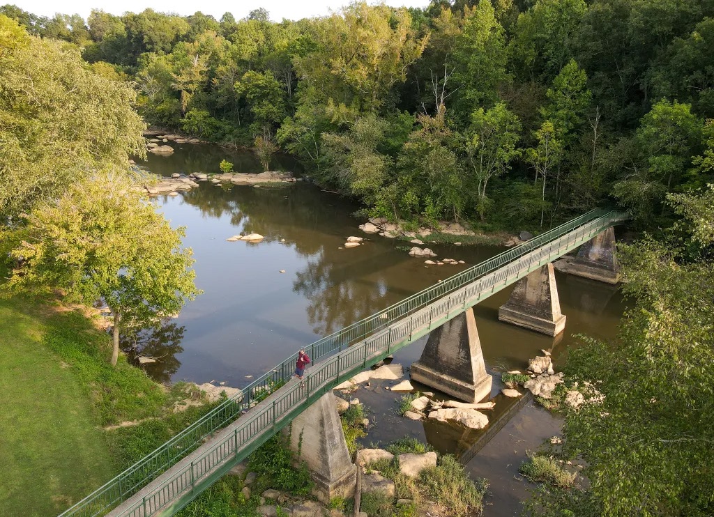
Faith Rock Trail
1306 Andrew Hunter Road Franklinville, NC 27248
Particularly lovely at sunrise and sunset, this 0.74-mile natural surface trail takes you to the top of a 50-foot blue stone outcrop as it juts into Deep River. Thankfully, it will always be here as the preserve is protected in perpetuity by Piedmont Land Conservancy. From the trailhead address above, cross the historic bridge into woods with beautiful views of Deep River to the top of Faith Rock, a natural heritage site with rare plants.
Distance: 0.75 miles
Type: Loop
Difficulty: Easy Not ADA Accessible
Highlights: River, 50-foot Rock, History, Rare Plants
Map: www.alltrails.com/trail/us/north-carolina/faith-rock-nature-trail-loop
NC ZOO TRAILS
The North Carolina Zoo is the world’s largest Natural Habitat Zoo, with fascinating nature-based education programs and an unwavering commitment to wildlife conservation. But we also appreciate their love of trails on- and off-site! The NC Zoo has a system of free, public trails that journey through beautiful ancient land.
Purgatory Mountain Trail / NC Zoo on-site
4401 Zoo Parkway Asheboro, NC 27205
The Purgatory Mountain Trail begins at a trailhead on the northern end of the North America parking lot. The first 0.2 miles features an ADA accessible fine gravel section through the woods, ending once the trail intercepts a service road. Continue straight on across the road to the remaining 0.7 mile natural surface section through Oak Hickory Forest to Chestnut Oak forest at the top of Purgatory Mountain (elevation 928 feet). The trail is a slight incline but the farther up you go the more massive rocks and beautiful hardwood forest you’ll discover.
Distance: 0.9 miles one way
Type: Trail System
Difficulty: Easy
First 0.2 miles are ADA Accessible
Highlights: Woods, Seep, Rock Out-crops
Map: www.alltrails.com/trail/us/north-carolina/purgatory-mountain-via-north-carolina-zoo
Moonshine Run Trail / NC Zoo on-site
The Moonshine Run Trail splits off Purgatory Mountain Trail and circles around the west and north sides of the mountain before reaching a dead end. Weaving between some large boulders, this trail is packed with unique plant life and is a great addition to Purgatory Mountain Trail if you’re looking to gain more mileage.
Distance: 0.5 miles one way
Type: Trail System
Difficulty: Moderate
Not ADA Accessible
Highlights: Woods, Rock Outcrops
Map: www.alltrails.com/trail/us/north-carolina/moonshine-run-trail
Connector Trail / NC Zoo on-site
4401 Zoo Parkway Asheboro, NC 27205
The parking lot connector trail connects the North America and Africa parking lots and signage is posted at either trail entrance. The north end of the trail starts at Solar Pointe picnic area near the southern end of the North America parking lot. This trail has a stone dust surface and is a beautiful walk through the woods along a creek.
Distance: 0.7 miles one way
Type: Out and Back
Difficulty: Easy
Not ADA Accessible Highlights: Woods, Stream
Map: www.nczoo.org/sites/default/files/2022-05/Purgatory-Trail-Map.pdf
Mountain Laurel Trail / NC Zoo on-site
4401 Zoo Parkway Asheboro, NC 27205
The parking lot connector trail connects the Middle Mountain Trail to the Purgatory Trail. The side closest to the Purgatory trail passes by a patch of mountain laurel that the trail is named after.
Distance: 0.7 miles one way
Type: Out and Back
Difficulty: Easy
Not ADA Accessible
Highlights: Mountain laurel, ravine, creek
Map: https://www.nczoo.org/sites/default/files/2022-05/Purgatory-Trail-Map.pdf
Middle Mountain Trail / NC Zoo off-site trailhead
Woodell Country Road Asheboro, NC 27205
This trail branches off to the left from the Purgatory Mountain Trail and heads north along a rocky ridge to the top of Middle Mountain. From there it continues down to a new trailhead on Woodell Country Road near Humble Mill Road. This trail is a gradual climb through a beautiful mature forest from either trailhead. This trail continues the theme of the area with unique rocky outcrops and significant natural features.
Distance: 0.75 miles one way
Type: Trail System
Difficulty: Moderate
Not ADA Accessible
Highlights: Woods, Stream, Rock Outcrops
Map: www.alltrails.com/trail/us/north-carolina/middle-mountain-via-north-carolina-zoo
Springs Trail / Off-site (By Appointment Only)
To make a reservation, call 336-879-7717, Monday-Friday during working hours. Located at Ward Nature Preserve at the headwaters of Bachelor Creek just south of the Zoo. This hiking trail is a 1.7-mile loop with two bridges that offer scenic views of the meandering creek and fern-covered slopes. The mature hardwood forest is brimming with wildlife, including a diversity of songbirds, box turtles and white-tailed deer.
Distance: 1.7 Miles
Type: Loop
Difficulty: Moderate Not ADA Accessible
Highlights: Headwaters of Bachelor Creek
Map: www.nczoo.org/experiences/attractions/hiking-trails
Ridge’s Mountain Nature Preserve / Off-Site (By Appointment Only)
Call 338-879-7717 for permission to access the trail.
Ridges Mountain is a State Nature Preserve with 270 acres managed by the NC Zoo and the Piedmont Land Conservancy. The trail follows the crest of the mountain. The first half of the trail is fairly level and follows an old road to a clearing.
At the clearing, a short trail leads east to an upland pool. The second half of the trail is narrower, steeper and rockier with large boulders. It ends just short of the southern summit near a large boulder area. (The southern summit is private property and does not belong to the Zoo.) Due to the rare plants and upland pools, trail users must stay on the trail.
Distance: 0.9 Miles
Type: Out and Back
Difficulty: Moderate Not ADA Accessible
Highlights: Large Boulders, Woods, Upland Pools
Map: www.nczoo.org/blog/discover-ridges-mountain-nature-preserve-hidden-gem
UPPER UWHARRIE TRAILS
Mt. Shepherd (Check-in Required)
1045 Mt Shepherd Rd Ext off of NC 64 West, Asheboro, NC 27205
Mount Shepherd Retreat Center is part of the Western North Carolina Conference of the United Methodist Church. Hikers must check in and sign liability waivers at the Retreat Center Office before using the trails and tower. Please call the office ahead of your trip to schedule a time to hike. (336-629-4085). With 542 acres and a lake, Mount Shepherd has several miles of hiking trails. The most popular hike
is to the top of Shepherd Mountain, the tallest point in the county, and the second highest peak in the Uwharrie Mountain chain. This 1.5 mile round trip hike goes straight up to the top along a rocky trail and features an observation tower, from which you can see much of the North Carolina Piedmont. On a clear day you can see Pilot Mountain, Hanging Rock and the Sauratown Mountains, in addition to the cityscapes of Greensboro, Winston-Salem and High Point.
Distance: 1.7 miles round trip
Type: Trail System
Difficulty: Moderate to Strenuous Not ADA Accessible
Highlights: Highest Peak in Randolph County, Views, Forest
Map: www.alltrails.com/trail/us/north-carolina/mt-shepherd-trail
Camp Caraway(Check-in Required)
4756 Caraway Mountain Road Sophia, NC 27350
Camp Caraway is operated by the State Baptist Convention of NC. Hikers must check in at the camp office to use these trails. Camp Caraway and Camp Mundi Vista across the road have a variety of trails including Caraway Mountain and Slip Rock Mountain. Maps are available at the office.
Distance: Various
Type: Trail System
Difficulty: Moderate
Not ADA Accessible
Highlights: Mountain Views, Woods
Map: www.alltrails.com/trail/us/north-carolina/mt-shepherd-trail
Caraway Forks Trail / Caraway Creek Preserve
829 Jerico Road, Asheboro NC.
This loop takes you through a full NC nature experience. You will hike uphill to a bluff with views of the Caraway Creek from a bird’s-eye view, and down to the 500-foot historic check dam. Just after leaving the dam, keep an eye out for North Carolina’s biggest short leaf pine tree. Take the Caraway Forks Spur Trail to see the confluence of Little Caraway Creek and Caraway Creek.
Distance: 0.7 miles
Type: Loop
Difficulty: Moderate Not ADA Accessible
Highlights: Dam, Views, Caraway Creek, State Champion Tree
Map: www.piedmontland.org/carawaycreekpreserve/
Laurel Loop / Caraway Creek Preserve
829 Jerico Road, Asheboro NC.
This moderate trail features a tunnel of Mountain laurel in the spring, and views of Caraway Mountain in the winter. It is moderately hilly yet provides you with an interesting walk through nature. This moderate hike is sure to give you a great photo spot year round.
Distance: 1 mile
Type: Loop
Difficulty: Moderate
Not ADA Accessible
Highlights: Views, Mountain Laurel
Map: www.piedmontland.org/carawaycreekpreserve/
Burl Trail / Caraway Creek Preserve
829 Jerico Road, Asheboro NC.
Spot old farming equipment along the trail! This land was once used for farming and had an old wagon road through it. The land has lived to tell the tale and hu-mans have left behind hints of the history!
Distance: 0.6 Miles
Type: Loop
Difficulty: Easy
Not ADA Accessible
Highlights: Old farming Equipment
Map: www.piedmontland.org/carawaycreekpreserve/
Winged Elm Trail / Caraway Creek Preserve
829 Jerico Road, Asheboro NC.
This trail shows you beautiful rock outcrops and along marshland and then turning up a ravine where the trail becomes a flat and wide old wagon road. The trail connects the Connector Trail to the Burl Trail. To arrive at the entrance, follow the pine path to the connector trail to reach the entrance on your right.
Distance: 0.6 miles
Type: Out and back
Difficulty: Easy
Not ADA Accessible
Highlights: Rock outcrops, creek.
Map: www.piedmontland.org/carawaycreekpreserve/
Old Jericho Road / Caraway Creek Preserve
829 Jerico Rd, Asheboro NC.
Like the Winged Elm Trail, this trail shows you beautiful rock outcrops and marshland and turns up a ravine where the trail becomes a flat and wide old wagon road. The trail connects the Connector Trail to the Burl Trail. To arrive at the entrance, follow the Pine Path to the connector trail to reach the entrance.
Distance: 0.6 miles
Type: Out and back
Difficulty: Easy
Not ADA Accessible
Highlights: Rock outcrops, creek.
Map: www.piedmontland.org/carawaycreekpreserve/
UWHARRIE NATIONAL FOREST TRAILS
Pisgah Covered Bridge
6900 Pisgah Covered Bridge Road Asheboro, NC 27205
Located near the Uwharrie National Forest, the Pisgah Covered Bridge is a historical and cultural treasure. The Bridge was built in 1911 and then refurbished by the NC Zoo in 2003 when the loop trail was added. It’s one of only two covered bridges remaining in North Carolina and the only one that is accessible to the public. The crushed gravel loop trail around the area is short at 0.25 miles, but shows off a variety of flora, including tunnels of Mountain Laurel. This is a wonderful place to stop, especially as a bonus to the other beautiful trails in the Uwharrie National Forest.
Distance: 0.25 miles
Type: Loop
Difficulty: Easy
ADA Accessible
Highlights: Historic Bridge, Creek
Map: www.alltrails.com/trail/us/north-carolina/pisgah-covered-bridge-loop
Birkhead Mountains Wilderness
Near NC 49 southwest of Asheboro, NC 27205 (see trailheads below)
The Birkhead Mountains Wilderness is the largest area of continuous trail in the county with 15 miles of trails to explore on 4,800 acres of wilderness. It’s the only wilderness in the Piedmont. Many of the trails were constructed by a local scout group in the late 1960s which became part of the 40-mile Uwharrie Trail. The Birkhead Mountains Wilderness is a great spot for camping and filled with history.
Located at the southwestern corner of Randolph County sits the beautiful Birkhead Mountains Wilderness and the surrounding Uwharrie National Forest. Coated in ferns and cut up by bubbling creeks, this historic wilderness will take some time to fully explore, but it’s SO worth it!
This trail system can be accessed by three different trailheads:
■ Thornburg: Near 3935 Lassiter Mill Rd, Asheboro, NC 27205
■ Robbins Branch: Robbins Branch Rd off of Lassiter Mill Rd south of Thorn-burg Trailhead, Asheboro, NC 27205
■ Tot Hill Farm: Tot Hill Farm Rd near golf course, Asheboro, NC 27205
Check out the online map to patch together your intended route into this magical wilderness.
Distance: 15 miles total
Type: Trail System
Difficulty: Moderate to Strenuous Not ADA Accessible
Highlights: Wild forests, bubbling creeks, historic gold mines
Map: www.alltrails.com/parks/us/north-carolina/birkhead-mountains-wilderness
Uwharrie Trail
See addresses below
The Uwharrie Trail extends 40 miles from Tot Hill Farm Trailhead southwest of Asheboro through the Birkhead Mountains Wilderness and on South to the NC 24/27 Trailhead near Troy. In addition to the trailheads within the Birkhead Wilderness, the Uwharrie Trail in Randolph County has two trailheads – Luther Place and Joe Moffitt. These trailheads cover three miles of trail including over King Mountain (1020 feet), the highest point on the Uwharrie Trail. A 2.5-mile trail from a future trailhead on High Pine Church Road intersects with the trail about 0.6 miles from the Luther Place Trailhead. From the Joe Moffitt Trailhead, the UT continues south into Montgomery County to Little Long Mountain and Jumping Off Rock Trailhead.
■ Walkers Creek Trailhead: 6871 High Pine Church Rd.
■ Luther Place Trailhead: Private road near 8733 Pisgah Covered Bridge Rd, Asheboro, NC 27205. Trailhead is a gate at the end of a 200 ft private drive on the left.
■ Joe Moffitt Trailhead: 998 Thayer Road (SR1305)
Distance: 3 miles
Type: Trail System
Difficulty: Moderate Not ADA Accessible
Highlights: Highest point on the Uwharrie Trail, Woods, Small Streams
Map: www.alltrails.com/parks/us/north-carolina/uwharrie-national-forest